LAND USE
LAND USE
Land Use
Land use planning is the allocation of land into certain categories of development, such as residential, commercial, industrial, and mixed-use. A variety of factors influence where each type of land use is located, including market demand, the existing and planned transportation network, and availability of infrastructure such as water and wastewater services. During a comprehensive planning process, city planners research trends and external drivers like job growth which may impact the future distribution of land uses.
Land use decisions have long term impacts. Decisions about how land develops are deliberate and made in accordance with established city policies. The continued interest in higher density spurred by rising land values and concerns about housing affordability will yield new forms of development. However, any changes to the existing suburban form will be gradual.
Current Development Patterns
Round Rock, like Central Texas in general, is a highly desirable area with a thriving economy and exemplary public schools. The city continues to transition from a predominately bedroom community serving Austin into a self-contained community offering a wide variety of opportunities for its residents. While the predominant land use remains single-family, significant changes have been made downtown, and higher-density developments are on the horizon at strategic locations across the city.
As the Austin area expands and traffic becomes more of an impediment to mobility, Round Rock has become a more attractive entertainment and dining destination for residents. Recent publications have identified a focus on entertainment, fitness, wellness, food and beverage uses as people seek to visit locations that provide an experience or service, rather than a product. The trend towards high-density multifamily development with restaurants, bars and entertainment nearby is likely to occur between 2020 and 2030.
Future Land Use
The 2010 to 2020 Plan period yielded rapid growth which began to reshape the land use patterns in the city. This growth is expected to continue throughout the course of the Round Rock 2030 Plan period. Accordingly a sensible land use strategy adopted by City Council is imperative to ensure the organized growth of the community.
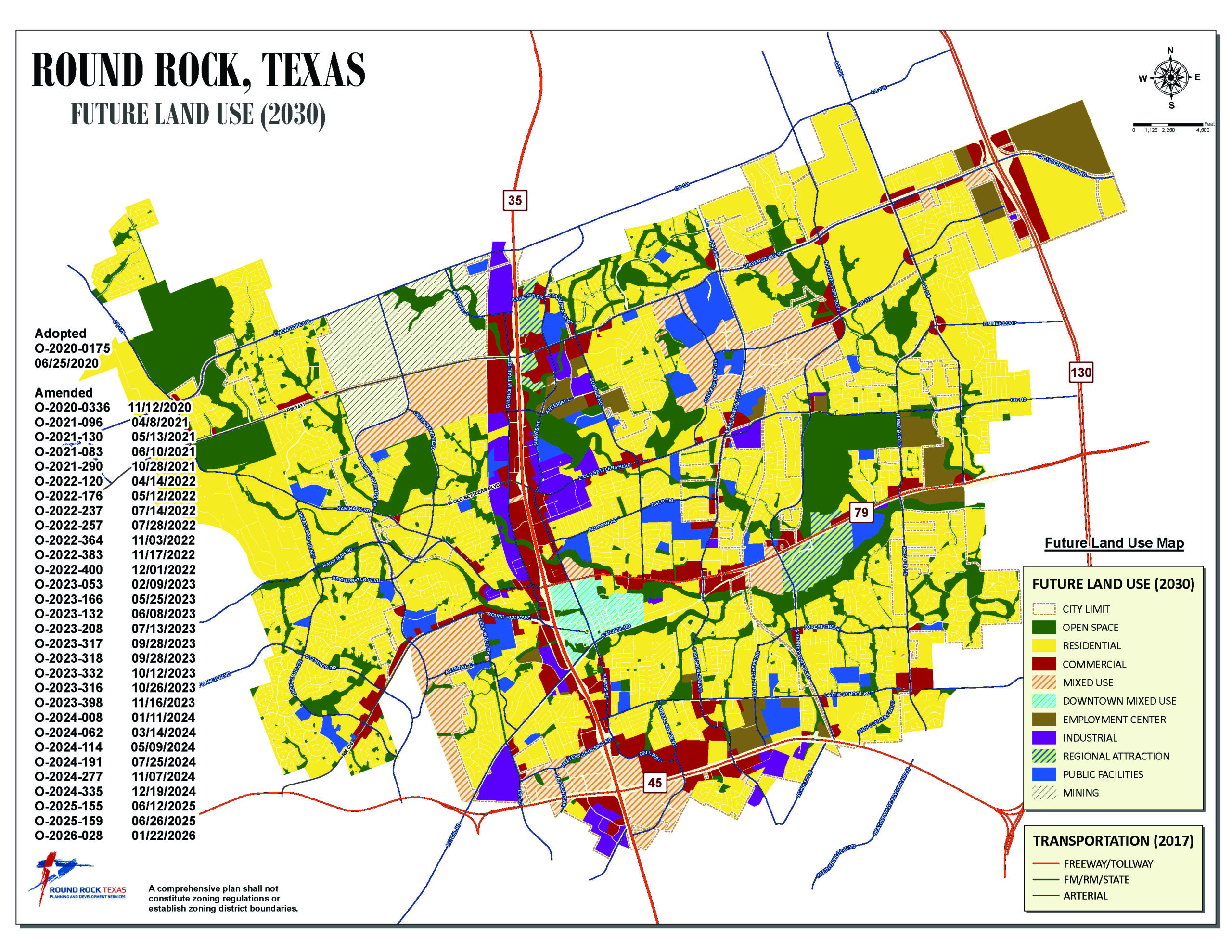
The primary tools for defining a land use strategy are the Future Land Use Map (FLUM) and location criteria, which together serve as a guide for evaluating proposed changes to land use. The FLUM depicts various land use types such as residential, commercial, industrial, and open space. Location criteria further define where specific uses within each designation may be located. Overall, the FLUM is a generalized representation of the future land uses for Round Rock and is not intended to be parcel specific. The FLUM is not a zoning ordinance.
Any zoning or land use decision regarding a property should be consistent with its classification in the FLUM and associated location criteria. The FLUM is a living document that is amended to reflect changing development and market trends. Amendments to the FLUM require a recommendation by the city’s Planning and Zoning Commission and approval by the City Council.
Future Land Use Map (FLUM)
Every ten years, the city evaluates the entire FLUM and adopts the map as part of its comprehensive planning process. The location criteria and FLUM are developed by combining the city’s goals and residents’ preferences with objective analysis of current land uses, existing and planned transportation and utility infrastructure, natural features, and the city’s policy goals and overall development needs.
- The City Council (elected by the residents) uses the FLUM to guide policy decisions and develop land use regulations.
- The Planning and Zoning Commission (residents appointed by the City Council) uses the FLUM when making recommendations to the City Council regarding proposed zoning amendments or land use regulations.
- City staff use the Comprehensive Plan to evaluate whether a development proposal is consistent with the FLUM and its location criteria. Planners also communicate the Plan policies to developers who are conducting due diligence for a project.
- Developers use the FLUM to identify properties where development proposals are most suitable.
- Utility service providers and other government entities use the FLUM to plan major infrastructure and service facility investments. This includes county governments, the school district, etc.
- Residents and property owners use the FLUM to evaluate how the city will develop in the future.
- The economy and population of the Central Texas region will continue to grow at a faster pace than most of the United States. Land prices will continue to rise as a consequence of this demand.
- Round Rock will continue to transform into a prosperous mid-sized city, strengthening its role as a major center of economic activity in Williamson County and Central Texas.
- Increased regional attractions, higher education campuses, medical facilities, sports tourism, and destination retail will further help Round Rock establish an identity apart from Austin.
- Single-family development will continue to be the predominant housing choice for residents moving to Round Rock. Lot sizes will likely be smaller and a variety of ownership options will be necessary to address affordability.
- Mixed-use and multifamily development will increase as residents seek different types of residential forms to counteract increased land values that make traditional single-family homes less affordable.
- The FLUM depicts planned land uses for the community. The map establishes the general pattern of future land use as appropriate for achieving the community’s goals and objectives.
- The text in this section provides a more detailed explanation of the land use designations depicted on the FLUM and provides location criteria to guide planning decisions such as zoning and the extension of utility infrastructure.
- In accordance with Section 213.005 of the Texas Local Government Code, the FLUM contains the following statement in a clearly visible format: “A comprehensive plan shall not constitute zoning regulations or establish zoning district boundaries.”
- The FLUM is not the city’s official zoning map. Rather, it is a guide for decisions concerning future land use. The FLUM is primarily implemented through zoning and subdivision ordinances, the construction of new infrastructure, and through other approved means which fulfill policy objectives, such as programs that establish capital improvement priorities, area studies, and neighborhood plans. The zoning ordinance text
and map determine where specific development requirements apply to a particular property. - The FLUM is intended to provide an overall framework for guiding the actions of the different entities responsible for determining the city’s future. The FLUM should be reviewed on a regular basis in order for the city to realize the full benefits of coordinated development over the long-term.
- Providing a zoning designation to a specific tract of land is inappropriate without considering the land use designations assigned by the FLUM as well as an analysis of existing transportation facilities, utility infrastructure, and abutting uses.
- Rezoning or other development approvals for land uses not consistent with the FLUM should not be approved until this Plan has been amended as necessary to provide for such land uses.
Northeast
The Northeast part of the Plan Area is where the majority of new single-family development is expected. The most recent neighborhoods include Vizcaya, Salerno, and University Heights, which contain almost 3,000 lots. In addition, the Avery PUD contains 900 acres and has entitlements for single-family, multifamily and substantial mixed-use development. Furthermore, there are approximately 1,900 acres of undeveloped land on which the city has made agreements with the owners ensuring that any future development can become part of the city and subject to the city’s land use authority.
Southwest
The Southwest part of the Plan Area contains a large undeveloped area under single ownership, which is bisected by SH-45. Single ownership benefits the comprehensive planning process because land does not have to be assembled by numerous entities. Approximately 700 acres are within the city’s ETJ and are accessible from CR 172 and RM 620. The planned Apple Inc. campus is to the west, outside of the city limits; however, it will have an impact on housing demand and associated business activity in Round Rock.
East on US 79
The property on the south side of US 79 at the intersection with Kenney Fort Boulevard contains several hundred acres, a portion of which is the currently under construction as the Kalahari Resorts project. Kalahari Resorts will include 975 hotel rooms, 150,000 square feet of convention space, a 223,000 square foot indoor water park, an 80,000 square foot indoor theme park, resort-style pools, retail, restaurants and a spa, creating an anchor for additional regional attractions. This project is only on a portion of the available land to the east of Kenney Fort Boulevard, with nearly 150 acres remaining undeveloped. To the west of Kenney Fort Boulevard there is an additional 100 acres which has the potential for mixed-use development.
Downtown
The Henna Tract, a single-family estate containing about 30 acres at the southeast corner of US 79 and Mays Street and along the northern bank of Brushy Creek, will likely develop as a mixed-use center close to downtown.
South/Central
Approximately 65 acres south of SH-45 and west of Greenlawn Boulevard is in the planning and pre-development stages for a mixed-use development called The District, which will be comprehensively designed with moderate to high-density residential, office, hotel, retail, restaurant, and entertainment uses.
Western ETJ
Mayfield Park is undeveloped park land at the southeast corner of RM 1431 and Sam Bass Road containing 244 acres. The city has plans for it to become a “Community Destination Park”, with potential activities including archery, zip lines, adventure ropes courses for all ages, nature center, swift-water channel for rafting and kayaking, fishing and canoe launches, and miles of natural, concrete, and equestrian trails.
The FLUM should be reviewed on a regular basis in order for the city to realize the full benefits of coordinated long-term development. While Round Rock does a large-scale re-examination of its FLUM every ten years, additional amendments may be made in the interim years to both the FLUM and location criteria. Amendments are typically substantiated by a comprehensive study that takes into consideration several factors, including but not limited to changing market conditions, changing demographics, changes to the transportation network, availability of utilities, and surrounding land use changes.
Location Criteria
Location criteria are contained within Round Rock 2030 to ensure the appropriate siting of land uses and ultimately to guide zoning decisions. They are developed using planning principles and City Council direction through plan adoptions and zoning approvals over time. All of the future land use designations on the FLUM have associated location criteria. The future land use categories on the FLUM are intentionally broadly defined, and location criteria are more specific than the land uses identified on the FLUM because they are used to organize land uses relative to each other rather than to apply specific development standards or densities.
The Open Space land use designation is used for any parcel, tract of land, or water feature that is either designated as a public park or private amenity, or which consists of floodplain land adjoining a watercourse or drainage way. Since floodplain land is inundated by floodwater in a storm, development is generally limited to recreational and/or drainage uses.
Open Space Location Criteria
Municipal parks are located according to the city’s adopted plan for parks and recreational facilities. Floodplain land is defined by the natural creeks and waterways in the area.
The Residential land use designation is used for any parcel or tract of land that is appropriate for dwelling units. Non-residential uses, such as low-rise offices and neighborhood commercial businesses, are considered complementary to residential since they provide goods and services to neighborhoods. The descriptions and location criteria for low-rise offices and neighborhood commercial are contained in the Commercial land use section.
Single-family residential dwelling units are designed to accommodate a living area for one family, while two-family dwelling units have separate accommodations for two families within the same structure.
Single-Family Location Criteria
The location of single-family and two-family housing should minimize potential conflicts with non-residential uses.
Single-family garden style residential is a type of development in which single-family dwelling units are arranged around a system of private access drives and which contains amenities for the residents.
Single-Family Garden Style Location Criteria
- Maximum of approximately 30 acres of net developable area;
- Primary access allowed via an arterial roadway or collector street;
- A property characterized by:
- A shape, size and/or physical constraints which cause it to be otherwise difficult to be developed for other single-family uses; or
- An infill location, within a previously built area which is already served by water and wastewater utilities.
- Is not adjacent to an existing or planned single family garden style residential development.
Multifamily residential is a type of housing where three or more dwelling units attached to one another. An apartment building is a structure in which units share common walls and/or floors and ceilings with other units, with each unit having single access from a shared hallway or walkway. A townhouse is a structure in which dwelling units share one or more wall(s) with an abutting unit, each unit occupying space from ground to roof and having front and rear walls open directly to the outside for access.
Multifamily development is further characterized by the unit density, measured by units per acre:
- Low-density multifamily – not to exceed 12 units per acre;
- Medium-density multifamily – not to exceed 20 units per acre; and
- Urban multifamily – exceeds 20 units per acre.
Low-Density Multifamily Location Criteria
- Primary access allowed via arterial roadway or collector street; and
- Direct access to abutting single-family neighborhoods is discouraged unless integrated as part of a master planned community or as required to implement transportation network policy objectives; and
- Low-density multifamily developments shall not be located immediately adjacent to other low-density multifamily developments; they must be separated by open space such as parkland or natural features.
Medium-Density Multifamily Location Criteria
- Primary access allowed via arterial roadway; and
- Located near existing or planned commercial nodes (areas of commercial activity); and
- New medium-density multifamily buildings shall be not be located within 500 feet of any single-family neighborhood or one-half (1/2) mile of any existing or zoned medium-density or urban multifamily use.
Urban Multifamily Location Criteria
Urban multifamily should be located near employment centers or major transportation or commercial nodes.
Urban/high density multifamily is characterized by living units with an attached parking structure, located within an activity center consisting of employment, retail, educational facilities, and a transportation node.
The Commercial land use designation is used for any parcel or tract of land that is appropriate for the provision of retail sales and services to the public. Commercial uses can serve neighborhood, community and regional customers. Neighborhood Commercial uses, such as personal services, fast-food restaurants, convenience stores, medical and dental offices and professional offices (low-rise office – two story maximum), are typically located at the entrance to neighborhoods, at the intersection of a collector road and an arterial road. These uses are typically active during the day and are therefore not disruptive to nearby residents. These uses can therefore be located in an area of the FLUM that is designated for residential, so long as the location criteria are met. Commercial uses, such as grocery stores, full-service restaurants, hotels, pharmacies and other large retail establishments, and mid-rise offices (five story maximum) are typically located at the intersection of two arterial roadways. These uses are active during the day and into the evenings, making them less suitable for location adjacent to a neighborhood. Regional commercial uses, such as shopping centers, destination retail centers, car dealerships, and “big box” retail are typically located along property with highway frontage. These uses serve both local customers and those from the area outside of the local area.
Beginning in 2002, the city’s zoning code contained two commercial zoning districts: C-1 (General Commercial) and C-2 (Local Commercial). In 2005, the C-1a (General Commercial – Limited), was adopted as an update to the C-1 (General Commercial) zoning district. The C-1a district prohibits some uses that were allowed in C-1 and restricts others or allows them only by special exception. For example, car sales and related uses were restricted to properties that have highway frontage. The C-1a district replaced the C-1 district for any new requests for general commercial zoning.
Neighborhood Commercial Location Criteria
- Located at the entrance to or with convenient access to an adjacent residential neighborhood; or
- At the intersection of a collector street and an arterial roadway or at the intersection of two arterial roadways; or
- An extension, not located at an intersection, of an established commercial area that does not conflict with adjacent residential uses.
Commercial Location Criteria
- At the intersection of two arterial roadways or an arterial/major collector; or
- At an extension of an established commercial area that does not conflict with adjacent residential uses.
- Some uses are appropriate only when located on property with highway frontage.
Regional Commercial Location Criteria
- Located with frontage on a designated highway.
- An extension of an established commercial area that does not conflict with adjacent residential uses.
Mid-Rise Office Location Criteria
- Frontage on a designated arterial roadway or freeway/tollway.
- Not to be located adjacent to existing or planned single-family neighborhoods unless appropriate setbacks and height are established.
Low-Rise Office Location Criteria
- Located at the entrance to or with convenient access to an adjacent residential neighborhood; or
- At the intersection of a collector street and an arterial roadway or at the intersection of two arterial roadways; or
- An extension of an established non-residential area that does not conflict with adjacent residential use.
The Mixed-Use land use designation is used for any parcel or tract of land that is appropriate for the combination of residential and complementary non-residential land uses. Mixed-use can be on a large site with the uses combined on the site or on a small site with the uses combined in a single building.
A redevelopment site, which is small tract of land with existing development to be removed or repurposed, can accommodate new or repurposed small scale mixed-use development. This type of development could incorporate low-density multifamily, retail and live/work units of five stories or less. Design should incorporate a pedestrian orientation and connections to the existing street grid.
A greenfield site, which is a large tract of land which has not been developed and therefore contains no development-imposed constraints, is a site on which a new, large scale mixed-use development could be located. This type of development could incorporate retail, restaurant, hotel, commercial, multifamily, employment centers, and medical offices. Ideally these would be built as a concentrated cluster of mid-rise to high-rise residential and commercial buildings, reaching up to twelve stories in height, in conjunction with plazas and open spaces. It is also important that the proximity of the different land uses would allow for increased pedestrian use. Some buildings should be built to abut sidewalks to provide a pedestrian streetscape.
Mixed-Use Location Criteria:
This land must be located so that the mixed-use is compatible with the surrounding area and is supported by employment and transportation infrastructure. Designation of an area for mixed-use generally requires the area to have certain characteristics which support this combination of uses.
- Redevelopment mixed-use should be located on small lots along commercial collector or arterial roadways where the desired development or redevelopment cannot be accommodated with existing commercial district standards.
- Greenfield mixed-use should be located on tracts a minimum of ten acres in size at major intersections where the transportation infrastructure efficiently accommodates high traffic volumes, including the potential for mass transportation.
The Downtown Mixed-Use land use designation is used for the city’s historic downtown area, which is bordered by IH-35 on the west, the Union Pacific railway line on the south, and Brushy Creek on the north and east. This area originally functioned as the commercial center of the adjoining residential neighborhoods and the surrounding community. Some general characteristics of the area include:
- a relatively concentrated cluster of low-rise residential and commercial buildings, reaching no more than three stories in height and extending across a limited number of city blocks;
- buildings constructed in close proximity to sidewalks;
- an extensive sidewalk system that is fully integrated and with all points easily accessible by walking due to the relatively small size of blocks; and
- parking located on the street or in centralized parking lots and multi-level garages.
The Downtown Mixed-Use area is further defined by the Downtown Master Plan and by the zoning districts established following that Plan’s adoption. The downtown business district is currently zoned to allow for retail, office, restaurant and entertainment uses with limited residential on upper stories or as live/work units, creating an active and pedestrian-friendly streetscape. The immediate surrounding area to the north and west is zoned for moderate density residential and commercial development, combining complementary residential and commercial uses in the same building, on the same site, or in the same block. The area to the east is zoned to allow single-family and limited commercial uses in structures that are single-family residential in style. These limited commercial uses include bed and breakfast businesses, offices, live/work units, and very limited retail uses including personal services, artisanal production, and boutique shops.
The Employment Center land use designation is used for any parcel or tract of land intended for office, research and development, and light manufacturing activities that do not involve the need for outdoor loading docks. Limited commercial support services, such as day care centers, health clubs, retail sales and services and restaurants, are also appropriate.
Employment Center Location Criteria
Employment Center developments are best located on land which is well served by the transportation and utility systems.
These developments may be located near single-family or two-family residential neighborhoods, however they should not be directly adjacent to them, but should be located where there is an intervening land use.
The Industrial land use designation is used for any parcel or tract of land which is to accommodate the manufacturing, production, and processing of goods, along with associated warehousing and offices. Examples of uses permitted in this category include manufacturing and assembly operations, food processing, office/warehouse operations and heavy vehicle and equipment sales and repairs.
Industrial Location Criteria
- New industrial development shall not be permitted within 500 feet of single-family or two-family uses or within 500 feet of designated arterial roadways or future arterial roadways; and
- Little or no visibility from public view, other than from the adjacent roadway; and
- No adjacent residential or commercial development.
- New industrial development shall not be permitted within 500 feet of single-family or two-family uses or within 500 feet of designated arterial roadways or future arterial roadways; and
Light Industrial Location Criteria
- Direct access to a collector street or arterial roadway; and
- No adjacent residential development.
The Regional Attraction land use designation is used for any parcel or tract of land intended for use as an entertainment venue, shopping or spectator sports arena/stadium which draws participants from outside of the Round Rock area.
Regional Attraction Location Criteria
Intersections where available land extends across several city blocks and where the transportation infrastructure efficiently provides high traffic volumes, including the potential for mass transportation.
The Public Facilities land use designation is used for any parcel or tract of land which provides for government facilities and large institutions such as hospitals, medical centers, high schools, universities, and places of worship.
The Mining land use land use designation is used for any parcel or tract of land intended for land excavation for extracting minerals and similar substances. These are determined by land owned for existing mining operations
Influences on Land Use
Round Rock 2030 provides a thorough analysis of the city’s land use, including an overview of current land use patterns, future land use, and criteria for future development. City planners determined several topics that have a significant influence on land use within Round Rock.
Businesses and employers base their location decisions on a variety of factors including land value, availability of public infrastructure, the local regulatory environment, and quality of life. The city may influence these decisions by offering economic development incentives such as fee waivers and tax abatements.
Round Rock has added numerous major employers over the last ten years. These include Emerson Automation Solutions, UPS, Houghton Mifflin Harcourt, ProPortion Foods, and AirCo Mechanical. Combined these companies have brought over 2,500 new jobs to the city, and countless other companies have expanded their operations. Specialized industries that have been attracted to Round Rock include innovative manufacturing, life sciences and healthcare, technology and computing, and professional and financial services. Additionally, hospitality, tourism, entertainment, and retail have become major growth industries, anchored by Kalahari Resorts, the Dell Diamond, Round Rock Amphitheater (formerly Nutty Brown Amphitheater), IKEA, and Bass Pro Shops.
The city adopts and maintains a Transportation Master Plan which establishes the ultimate roadway network and protects adequate rights-of-way to meet future transportation needs. Transportation planning and land use planning work hand-in-hand to ensure organized growth. Thinking more strategically about land use-transportation relationships can lead to reduced vehicle miles of travel, improvements in air quality, increased walking, bicycling and transit use, economic and community revitalization, the preservation of neighborhood character, and a more visually appealing landscape. Communities of all sizes are beginning to consider transportation and land use as part of an interrelated system in which mobility and livability are in balance.
Access to water and wastewater utility infrastructure is a key driver of where and how development occurs. The cost of extending utilities great distances impedes development. One way the city manages growth is by requiring evelopers to bear the cost of extending or increasing the capacity of utilities to serve their development. The lack of utility infrastructure in the northeast portion of the city has caused that area to remain undeveloped until recently.
A Municipal Utility District (MUD) is a political subdivision of the State of Texas, one of several types of special districts that function as independent, limited governments. While the purpose of a MUD is to provide an alternate way to finance land development infrastructure, such as water, wastewater,
drainage, recreational and road facilities, its creation also determines the land uses within its boundaries. When MUDs are located within the city’s ETJ, the city has no zoning authority.
MUDs are primarily created for residential uses. There are ten MUDs within the city’s ETJ which are either fully or partially developed. Two additional MUDs are located within the city limits.
Annexation is the process by which cities expand their city limits. Since Texas counties do not have land use authority, cities often find it advantageous to expand their boundaries to utilize their zoning authority. Recent state egislation has limited annexation to situations where consent has been granted
by the property owner, which has the potential to hamper the city’s ability to manage growth. Prior to this change, cities were able to annex properties that were contiguous to their city limits at will.
As land continues to be developed, the city’s subdivision requirements mandate developers to donate parkland or make a payment in-lieu of parkland to help meet the need for future parkland. This ensures strategic growth of the park system and provides adequate parkland for ultimate build-out. Through this process, developers may donate land for public parkland or may seek credit for private parkland and recreational facilities that are later deeded to homeowners’ associations to meet the parkland requirements per the Round Rock Development Code. If land is donated as public parkland, it should be in accordance with Playbook 2030: Building a Connected Community, unless otherwise approved by the Director of Parks and Recreation.
Round Rock is committed to preserving architecturally, archaeologically, culturally and historically significant buildings and properties by maintaining a preservation program. The preservation of local landmarks fosters the creation of unique places that express the city’s heritage. Allowable land uses for historic properties are regulated by the property’s underlying zoning. The dded Historic Overlay (H) zoning requires that designated structures are preserved in their original form; however, the land uses often change over time. Preservation does not prevent land use changes but may limit the range of new uses to those that do not significantly impact a structure’s historic significance or integrity. Houses are routinely re-used as offices, restaurants or retail spaces with few exterior alterations. Selecting new uses that work with and enhance historic features present opportunities for a unique quality of place that cannot be created with new construction. To guide the city’s future preservation priorities, Round Rock 2030 includes a ten-year Historic Preservation Plan with details on the city’s preservation goals and objectives.
Round Rock 2030 incorporates the policy objectives contained in the following documents:
- Downtown Master Plan (adopted 2010) for downtown revitalization;
- Playbook 2030: Building a Connected Community (adopted 2018) for open space and parks resources;
- Transportation Master Plan (update adopted 2017);
- Transit Master Plan (adopted 2015) for development of a public transit system;
- Water System Master Plan (adopted 2014; update in progress);
- Wastewater System Master Plan (adopted 2014; update in progress);
- Stormwater Master Plan (adopted 2014; update in progress);
- Utility Profile and Water Conservation Plan for Municipal and Wholesale Water Use (adopted 2019).
A PDF of each plan is available for download on the About the Plan page.
Other Considerations
In addition to the influences listed in the Land Use section of Round Rock 2030 several other considerations for determining land use are included in the Infrastructure and Community Facilities and Services sections. The Infrastructure section includes department-written summaries of land-use related plans, goals, and strategies from the adopted plans of the Utilities and Environmental Services, Parks and Recreation, and Transportation Departments. The Community Facilities and Services section highlights how Arts and Culture, Police and Fire, Sports Management and Tourism, the Library, and planning-related services will support quality of life aspirations as the city grows.